
GARMIN BASECAMP

Garmin Adventures provides a free, interactive way for you to swap your stories with a community of fellow explorers, brag to your buddies about your travels, or let friends and family find your favorite spots. BaseCamp lets you plan outdoor activities, organize your data and share your adventures with others.

|
|
Feature: Plan a Trip
Use BaseCamp to plan your next hiking, biking, motorcycling, driving or off-roading trip. You can view maps, plan routes, and mark waypoints and tracks from your computer and then transfer them to your device.
Feature: Survey the Terrain
BaseCamp displays your topographic map data in 2-D or 3-D on your computer screen, including contour lines and elevation profiles. Load map data from your handheld device, or import maps you've downloaded or purchased on DVD or microSD™ card. Consider our TOPO series maps, which offer detail on a scale of either 1:100,000 or 1:24,000.
Feature: Geotag Photos
BaseCamp lets you geotag photos, associating them with specific waypoints. You can see the exact scenery at any given location. Transfer the photos to your handheld device, publish photos directly to Picasa™, or email your geotagged photos directly to friends or family so they can navigate right to your favorite spots in the future.
Feature: Create and Share Adventures
Garmin Adventures provides a free, interactive way to share your hikes, bike rides, road trips and more. Using BaseCamp, you can combine track logs, waypoints, geotagged photos, YouTube® videos and more into an adventure that gets published online. You can then email a link to your adventure to friends and family, share it on social media sites or even post it in your favorite forums. BaseCamp even makes it easy to follow in the footsteps of other travelers by allowing you to search for and download adventures.
Feature: Transfer Satellite Images
With BaseCamp and a BirdsEye Satellite Imagery subscription, you can transfer an unlimited amount of satellite images to your outdoor or fitness device and seamlessly integrate those images into your maps to get a true representation of your surroundings. It makes it easy to scout campsites, sources of water, potential hazards and more. If you prefer raster topographic maps, you can also download BirdsEye Select maps and pay only for the data you download.
Full Feature List:
Use BaseCamp to plan your next hiking, biking, motorcycling, driving or off-roading trip. You can view maps, plan routes, and mark waypoints and tracks from your computer and then transfer them to your device.
- Track Draw feature lets you trace your planned route and view elevation changes, helping you estimate the difficulty of a hike or bike ride.
- Plan the perfect scenic route for your next road trip, making sure your navigator takes you through certain waypoints.
- Play back your routes and tracks over time and save and share your adventure.
Feature: Survey the Terrain
BaseCamp displays your topographic map data in 2-D or 3-D on your computer screen, including contour lines and elevation profiles. Load map data from your handheld device, or import maps you've downloaded or purchased on DVD or microSD™ card. Consider our TOPO series maps, which offer detail on a scale of either 1:100,000 or 1:24,000.
Feature: Geotag Photos
BaseCamp lets you geotag photos, associating them with specific waypoints. You can see the exact scenery at any given location. Transfer the photos to your handheld device, publish photos directly to Picasa™, or email your geotagged photos directly to friends or family so they can navigate right to your favorite spots in the future.
Feature: Create and Share Adventures
Garmin Adventures provides a free, interactive way to share your hikes, bike rides, road trips and more. Using BaseCamp, you can combine track logs, waypoints, geotagged photos, YouTube® videos and more into an adventure that gets published online. You can then email a link to your adventure to friends and family, share it on social media sites or even post it in your favorite forums. BaseCamp even makes it easy to follow in the footsteps of other travelers by allowing you to search for and download adventures.
Feature: Transfer Satellite Images
With BaseCamp and a BirdsEye Satellite Imagery subscription, you can transfer an unlimited amount of satellite images to your outdoor or fitness device and seamlessly integrate those images into your maps to get a true representation of your surroundings. It makes it easy to scout campsites, sources of water, potential hazards and more. If you prefer raster topographic maps, you can also download BirdsEye Select maps and pay only for the data you download.
Full Feature List:
- Plan a multi-day trip and pick lodging, food and other stops using your maps and Yelp
- Transfer waypoints, geocaches, routes, and tracks to and from your GPS device.
- Create, view, edit, and organize waypoints, routes, and tracks.
- Find places, such as addresses, points of interest, and public land survey areas included in your detailed map data.
- Download, display, and transfer BirdsEye imagery to supported devices.
- Import, display and transfer Garmin Custom Maps to supported devices.
- Track Draw
- Printing the map, driving directions, and route and track profiles
- View in Google Earth
- Advanced geocache support
- Geotagging photos
- Photo waypoints
- Integrated support for publishing photos online
- Track and route play back
- Exchange custom waypoint symbols with selected devices
1. Verify Requirements

Windows® Requirements
|
|
|
2. Download the Garmin BaseCamp file name. Click on 'Download File' >>>>>>
|
| ||

3. Install by running the executable file (.exe). Follow the onscreen instructions to complete the update of your BaseCamp installation.
NOTE: If you experience problems when interacting with the map views, please make sure that you have installed current video card drivers.
Installation Instructions: MAC
1. Verify Requirements

Mac® Requirements
|
|
|
2. Download the Garmin BaseCamp file name. Click on 'Download File' >>>>>>
|
| ||

3. Install by Double-click the file to open it. A new Finder window will open. Locate and double-click on the 'Garmin BaseCamp' icon.
Follow the installer program's prompts to install Garmin BaseCamp.
Follow the installer program's prompts to install Garmin BaseCamp.
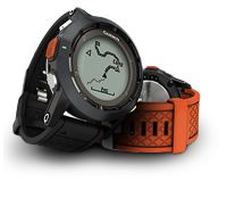
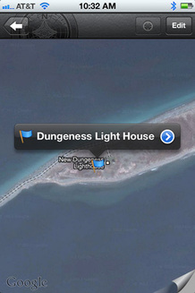
BaseCamp Mobile App
|
BaseCamp Mobile lets you supplement your fēnix™ outdoor watch or Oregon® 600 series handheld with the power of your smartphone. Easily manage and share the waypoints, routes and tracks you’ve logged on your trail-hardened device. Simply sync your fēnix or Oregon with your iPhone® to download your data using Bluetooth® 4.0 wireless technology.
|